
Residents of the Magdalen Islands and Maritime Provinces face the Fiona attack, a historic storm that made landfall this morning at approximately 4 a.m. EDT on the Canso Peninsula of Nova Scotia, with a pressure of about 931 MB and winds of about 150 km/h. If Fiona reached the Category 4 threshold this week with winds of 215 km/h, it changed its status to a non-tropical storm shortly before touching the Canadian coast.
WATCH: High winds, 100mm of rain: Fiona makes landfall
Analyzes must be done to determine whether Fiona has been affected by climate change, but science has already revealed several effects of warming on tropical storm formation.
Hurricanes draw their strength from warm waters. They form over the tropics, where the plentiful heat keeps them running for days. Even as they move away from the tropics to reach the North Atlantic, the Gulf Stream brings them warmth that can refresh or even intensify them off the eastern coast of the United States and Canada.
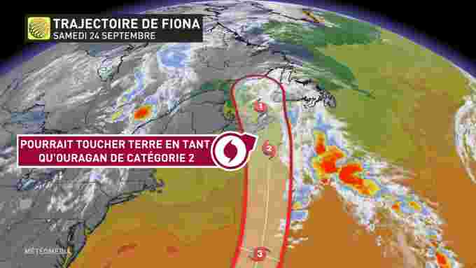 Category 3 Hurricane Fiona moved to 4 north of Bermuda, intensifying forecasts for its arrival on the Cape Breton coast (Weather Network)
Normally, the water is cold enough off the Maritimes, just north of the Gulf Stream, to quell tropical storms and slow their tracks before they hit Canada. The Canadian Hurricane Center of Environment Canada estimates that a category greater than 3 is “virtually impossible” here because the waters are so cold.
But we do know that the average ocean temperature is increasing due to climate change, which could have devastating consequences.
more severe storms
The latest studies of hurricanes have shown that their intensity increases over time and that climate change is likely to be the cause.
According to one of the study’s authors, Gabriel Vicki, in a statement issued by Princeton Press last April, “the proportion of Category 3 to 5 hurricanes has increased by 5 percent per decade since 1979.”
“Bigger, more severe hurricanes tend to do more damage than weaker storms, so a higher proportion of severe tornadoes is a concern,” he added.
Since many factors can explain the development of storms, the researchers note that they cannot be directly attributed to human-caused climate change. However, the trends are consistent with models, leading to their conclusion that climate change is “likely” responsible for the intensification of tropical cyclones.
The researchers also note that tornadoes intensify faster. As a recent example, let’s go back to Hurricane Harvey in 2017. As it passed over the Atlantic Ocean, it was only considered a tropical storm. After losing some strength while crossing the Yucatan Peninsula, it quickly intensified over the Gulf of Mexico to become a Category 4 hurricane in just two days.
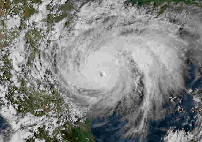 Satellite image of Hurricane Harvey at its peak Category 4 on August 25, 2017 (Source: GOES-16, NOAA)
Harvey has also shown another disturbing trend – tropical cyclones are moving slower and stagnating for longer periods. Moreover, the latitude at which it reaches its maximum is closer to the poles, and rising water levels increases the risk of flooding.
More frequent storms
The intensity of tropical cyclones is not our only concern. Researchers also want to know if they are more common. But there is a catch: the further back you go, the less reliable the hurricane data is. It is difficult to compare historical trends before the advent of radars and satellites.
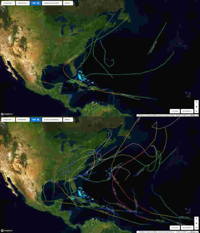 Hurricane movement in the North Atlantic according to NOAA data, comparing 1851 (top) with 2021 (bottom). Although there were 13 hurricanes in the 1851 data versus 21 in 2021, the difference is likely due to a lack of observations at the time. (Source: NOAA Historical Hurricane Tracks)
But new approaches help meet the challenge. In a study at the Massachusetts Institute of Technology, meteorologist and climatologist Kerry Emanuel used climate analysis to better understand official reports he might have missed.
Reanalysis involves entering historical weather data into various contemporary climate models. The results can then be compared to verify the accuracy of the simulations. Looking at the basic weather conditions that have caused hurricanes over the past 150 years in light of current models, Emanuel pointed out three important things: the number of hurricanes of all categories increased, the number of major hurricanes, and the number of hurricanes making landfall. .
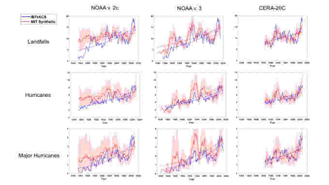 These graphs show the results of the three study models. Each graph contains historical data from the IBTrACS Archive (blue line), which produces a positive trend (dotted blue line). The red line in each graph represents the results of the MIT study, which also shows a positive trend (red dotted line) for hurricanes, major hurricanes, and hurricanes making landfall. (Emmanuel, 2021 / Nature Communications)
This finding has since been verified and confirmed by other researchers. However, the same trends are not observed in other world oceans.
writes Dr. Savin Chand, lead author of the new paper published in Nature Climate Change (and picked up by The Conversation).
More importantly, this happened when the warming caused by human activity also accelerated. The only exception to this trend is the North Atlantic Basin, where the number of tropical cyclones has increased in recent decades. »
according to Text by Scott SutherlandScience Editor at The Weather Network.